TAMPA, Fla. (WFLA) — The National Hurricane Center continues to monitor a number of systems in the Atlantic and the Gulf of Mexico Saturday evening.
Tropical Storm Paulette strengthened into a hurricane Saturday night, and is expected to bring strong winds and heavy rain to Bermuda when it nears the island on Sunday.
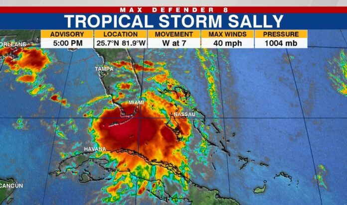
Tropical Depression Nineteen strengthened into Tropical Storm Sally just off the coast of South Florida Saturday afternoon. The storm is forecast to bring life-threatening storm surge and hurricane-force winds to portions of the northern Gulf Coast early next week.
Forecasters are also monitoring Tropical Storm Paulette, Tropical Depression Rene, and Tropical Depression Twenty, which formed over the central tropical Atlantic on Saturday.
Hurricane Paulette
Paulette strengthened into a hurricane as it moved toward Bermuda Saturday evening.
At 11 p.m., the storm had maximum sustained winds at 75 mph and was 385 miles southeast of the island territory. It was moving west-northwest at 14 mph.
Forecasters say hazardous conditions are expected to reach Bermuda by Sunday evening. The eye of the storm will be near or over Bermuda on Monday morning.
Further strengthening is possible as the storm moves away from Bermuda late Monday through Tuesday.
A Hurricane Watch is in effect for Bermuda.
Tropical Storm Sally
Sally is moving into the Gulf of Mexico this evening and is forecast to strengthen into a hurricane before making landfall in the northern Gulf Coast.
At 11 p.m. Saturday, the storm had maximum sustained winds of 40 mph and was located about 70 miles southwest of Port Charlotte, Florida. It was moving west-northwest at 8 mph.
Sally is expected to travel west-northwestward or northwestward over the Gulf this evening and reach the north-central Gulf on Sunday night or Monday.

It’s expected to reach the north-central Gulf Coast within a hurricane watch area on Monday night or Tuesday.
The storm is forecast to bring about 2 to 4 inches of rain to southern Florida and the Florida Keys on Saturday night.
A Storm Surge Watch is in effect for:
- Mouth of the Mississippi River to the Alabama/Florida Border
- Lake Pontchartrain, Lake Maurepas, and Lake Borgne
- Mobile Bay
A Hurricane Watch is in effect for:
- Grand Isle Louisiana to the Alabama/Florida border
- Lake Pontchartrain and Lake Maurepas including metropolitan New
Orleans
A Tropical Storm Watch is in effect for:
- Alabama/Florida Border to Ochlockonee River Florida
Tropical Depression Rene
Rene was reclassified as a tropical depression and is forecast to become a remnant low on Monday.
At 11 p.m. Rene had maximum sustained winds of 30 mph and was 1,.175 miles east-northeast of the Northern Leeward Islands.
Tropical Depression Twenty
Tropical Depression Twenty formed over the central tropical Atlantic early Saturday night.
The NHC said the system is poorly organized for now, but is expected to strengthen slowly over the next week.
At 11 p.m., it was located about 765 miles west-southwest of the Cabo Verde Islands. It is moving west-northwest at 10 mph.
Forecasters are also watching two disturbances—one in the Gulf of Mexico and the other off the coast of Africa.
The one in the Gulf has a low 20 percent of formation in the next five days, and the one near Africa has a medium 60 percent chance of development.
LATEST STORIES:


